
Published 2026-10-10
Keywords
- Unauthorised construction,
- spatial analysis,
- indicators,
- spatial autocorrelation,
- GIS
- Greece ...More
How to Cite
Copyright (c) 2026 Ourania Eftychiadou, Aristotelis Vartholomaios , Evangelos Asprogerakas

This work is licensed under a Creative Commons Attribution 4.0 International License.
Accepted 2026-10-03
Published 2026-10-10
Abstract
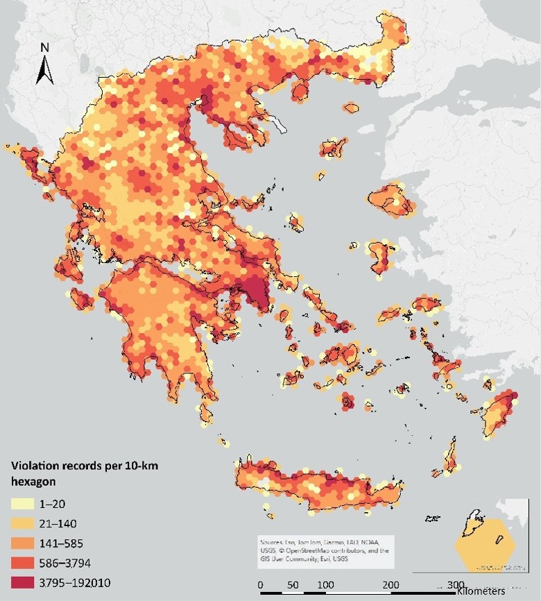
Unauthorised construction has been a persistent feature of spatial development in Greece, yet its geographical variation cannot be adequately captured by counts of recorded cases or total unauthorised building area alone. This study examines the officially recorded and legally regularised component of the phenomenon using administrative data from the Technical Chamber of Greece, comprising approximately 1.2 million declarations and more than 4.1 million violation records. A four-indicator framework is applied to distinguish complementary dimensions of unauthorised construction: relative severity, average scale, spatial intensity, and degree of integration into the building stock. Three indicators are calculated for 1,036 municipal units nationwide. The Unauthorised Share Ratio is examined separately for Athens and Thessaloniki using more detailed building-level data. The analysis combines descriptive and non-parametric statistics with Global Moran’s I and local correlation analysis. National correlations between severity, average scale, and spatial intensity are weak, indicating that these dimensions capture distinct characteristics of recorded unauthorised construction. All three indicators exhibit significant positive spatial autocorrelation, strongest for violation density (I = 0.546), while local correlations reveal marked geographical variation in both the strength and direction of their relationships. The analysis of Athens and Thessaloniki further identifies substantial intra-urban variation in the share of unauthorised area within the building stock. These findings demonstrate that recorded unauthorised construction does not follow a single spatial pattern and that its spatial structure is obscured when analysis relies solely on conventional aggregate measures. The proposed framework provides a transferable approach for examining the spatial differentiation of unauthorised development in other planning contexts where comparable administrative data are available.
Highlights:
- Develops four indicators of unauthorised construction across Greece.
- Severity, scale, and density show weak national but varying local associations.
- USR reveals strong intra-urban variation in Athens and Thessaloniki.
Downloads




References
- Akrofi, M. M., Avogo, F. A., & Wedam, E. A. (2019). Sustainable urban development and the challenge of unauthorized buildings: Assessing demographic drivers in peri-urban areas of Ghana. Journal of Housing and the Built Environment, 34(2), 571–598. https://doi.org/10.1007/s10901-018-09642-y
- Allen, A. (2003). Environmental planning and management of the peri-urban interface: Perspectives on an emerging field. Environment and Urbanization, 15(1), 135–148. https://doi.org/10.1177/095624780301500103
- Allen, J., Barlow, J., Leal, J., Maloutas, T., & Padovani, L. (Eds.). (2004). Housing and welfare in Southern Europe. Blackwell Publishing. https://doi.org/10.1002/9780470757536
- Anselin, L. (1995). Local indicators of spatial association—LISA. Geographical Analysis, 27(2), 93–115. https://doi.org/10.1111/j.1538-4632.1995.tb00338.x
- Benjamini, Y., & Hochberg, Y. (1995). Controlling the false discovery rate: A practical and powerful approach to multiple testing. Journal of the Royal Statistical Society: Series B (Methodological), 57(1), 289–300. https://doi.org/10.1111/j.2517-6161.1995.tb02031.x
- European Environment Agency. (2006). Urban sprawl in Europe: The ignored challenge (EEA Report No. 10/2006). https://www.eea.europa.eu/en/analysis/publications/eea_report_2006_10
- Fernandes, E. (2011). Regularization of informal settlements in Latin America. Lincoln Institute of Land Policy.
- Filippidis, D. (1990). For the Greek city: Postwar development and future prospects [in Greek]. Themelio.
- Fotheringham, A. S. (2009). “The problem of spatial autocorrelation” and local spatial statistics. Geographical Analysis, 41(4), 398–403. https://doi.org/10.1111/j.1538-4632.2009.00767.x
- Fotheringham, A. S., Brunsdon, C., & Charlton, M. (2000). Quantitative geography: Perspectives on spatial data analysis. Sage.
- Greece. (2013). Law 4178/2013: Treatment of unauthorised construction—Environmental balance and other provisions [in Greek]. Government Gazette of the Hellenic Republic, Series A, 174/8.8.2013.
- Greece. (2017). Law 4495/2017: Control and protection of the built environment and other provisions [in Greek]. Government Gazette of the Hellenic Republic, Series A, 167/3.11.2017.
- He, Y., Ma, W., Ma, Z., Fu, W., Chen, C., Yang, C. F., & Liu, Z. (2019). Using unmanned aerial vehicle remote sensing and a monitoring information system to enhance the management of unauthorized structures. Applied Sciences, 9(22), 4954. https://doi.org/10.3390/app9224954
- Hellenic Cadastre. (n.d.). GEOTEMAXIA_LEITOURGOUN_ON_gdb [Feature layer]. ArcGIS Online. https://www.arcgis.com/home/item.html?id=01932f081e7f43628ce271d9b7d80ae1
- Hellenic Statistical Authority. (n.d.). Digital cartographic data. https://www.statistics.gr/en/digital-cartographical-data
- Jenks, G. F. (1967). The data model concept in statistical mapping. International Yearbook of Cartography, 7, 186–190.
- Karadimitriou, N., & Pagonis, T. (2019). Planning reform and development rights in Greece: Institutional persistence and elite rule in the face of the crisis. European Planning Studies, 27(6), 1217–1234. https://doi.org/10.1080/09654313.2019.1579300
- Leontidou, L. (1990). The Mediterranean city in transition: Social change and urban development. Cambridge University Press. https://doi.org/10.1017/CBO9780511522208
- Maloutas, T. (2008). Housing provision models and family strategies in Greece. In M. R. P. d’Assunção Carlos (Ed.), The challenge of social policy reform in the XXI century: Towards integrated systems of social protection (pp. 311–329). I. Sideris.
- Marmaras, E. V. (2002). Planning and residential space: Theoretical approaches and aspects of Greek urban geography [in Greek]. Ellinika Grammata.
- Marx, C., & Kelling, E. (2019). Knowing urban informalities. Urban Studies, 56(3), 494–509. https://doi.org/10.1177/0042098018770848
- Moran, P. A. P. (1950). Notes on continuous stochastic phenomena. Biometrika, 37(1–2), 17–23. https://doi.org/10.1093/biomet/37.1-2.17
- O'Sullivan, D., & Unwin, D. J. (2010). Geographic information analysis (2nd ed.). Wiley.
- Osennyaya, A., Gura, D., Khakhuk, B., Dyakova, N., & Lytus, M. (2023). Automation of monitoring of unauthorized buildings. In A. Guda (Ed.), Networked control systems for connected and automated vehicles (Lecture Notes in Networks and Systems, Vol. 509, pp. 713–721). Springer. https://doi.org/10.1007/978-3-031-11058-0_71
- Polyzos, S., & Minetos, D. (2009). Informal housing in Greece: A quantitative spatial analysis. Theoretical and Empirical Researches in Urban Management, 4(2), 7–33.
- Polyzos, S., & Minetos, D. (2013). Informal housing in Greece: A multinomial logistic regression analysis at the regional level. European Spatial Research and Policy, 20(2), 57–85. https://doi.org/10.2478/esrp-2013-0011
- Polyzos, S., Minetos, D., & Niavis, S. (2013). Driving factors and empirical analysis of urban sprawl in Greece. Theoretical and Empirical Researches in Urban Management, 8(1), 5–29.
- Potsiou, C. (2014). Policies for formalization of informal development: Recent experience from southeastern Europe. Land Use Policy, 36, 33–46. https://doi.org/10.1016/j.landusepol.2013.07.010
- Roy, A. (2005). Urban informality: Toward an epistemology of planning. Journal of the American Planning Association, 71(2), 147–158. https://doi.org/10.1080/01944360508976689
- Shahraki, A. A. (2017). Urban planning and design in unauthorized neighborhoods using case studies. International Journal of Sustainable Built Environment, 6(2), 273–284. https://doi.org/10.1016/j.ijsbe.2016.09.005
- Somiah, M. K., Osei-Poku, G., & Aidoo, I. (2015). Relative importance analysis of factors influencing unauthorized siting of residential buildings in the Sekondi-Takoradi Metropolis of Ghana. Journal of Building Construction and Planning Research, 3(3), 117–126. https://doi.org/10.4236/jbcpr.2015.33012
- Son, H., & Kim, D. (2025). Deep learning-based detection of unauthorized buildings using aerial images: A comparative study. Journal of Korean Society for Quality Management, 53(3), 315–328. https://doi.org/10.7469/JKSQM.2025.53.3.315
- Technical Chamber of Greece. (n.d.). Υποστήριξη – Σύστημα δηλώσεων αυθαιρέτων κτισμάτων [Support – Unauthorised building declarations system]. https://web.tee.gr/authaireta/support/
- Tsenkova, S. (2012). Urban planning and informal cities in Southeast Europe. Journal of Architectural and Planning Research, 29(4), 292–305.
- Vartholomaios, A. (2025). Detection and clustering of urban form types with machine learning: Insights into Thessaloniki’s urban planning and evolution. Computational Urban Science, 5, 51. https://doi.org/10.1007/s43762-025-00206-9
- Wassenhoven, L., & Asprogerakas, E. (2026). Planning in transition: The case of Greece. Planning Practice & Research, 41(1), 1–14. https://doi.org/10.1080/02697459.2026.2614841
- Wassenhoven, L., Sapountzaki, K., Asprogerakas, E., Gianniris, I., & Pagonis, T. (2010). Spatial governance: Theory, European experience, and the case of Greece [in Greek]. Kritiki.
- Watson, V. (2009). Seeing from the South: Refocusing urban planning on the globe's central urban issues. Urban Studies, 46(11), 2259–2275. https://doi.org/10.1177/0042098009342598
- Zeković, S., Petovar, K., & Nor-Hisham, B. M. S. (2020). The credibility of illegal and informal construction: Assessing legalization policies in Serbia. Cities, 97, 102548. https://doi.org/10.1016/j.cities.2019.102548