
A Data-driven Approach to Assess the Need for Priority Treat-ment of Potentially Contaminated Sites (PCSs) in Slovenia
Published 2026-03-21
Keywords
- PCS management,
- soil protection,
- sustainable land use,
- multi-criteria decision-making model (MCDM),
- decision-support framework
- Slovenia ...More
How to Cite
Copyright (c) 2026 Tajan Trobec, Barbara Lampič, Blaž Repe, Katja Vintar Mally, Nejc Bobovnik, Lea Rebernik

This work is licensed under a Creative Commons Attribution 4.0 International License.
Accepted 2026-03-15
Published 2026-03-21
Abstract
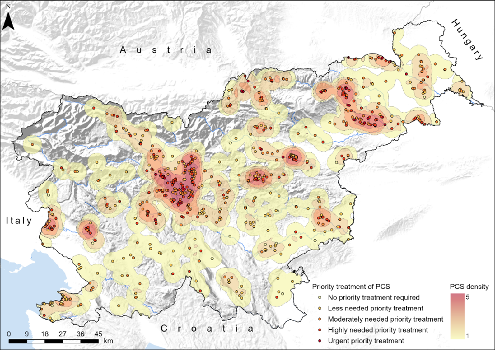
This paper presents a multi-criteria decision-making model for assessing the need for priority treatment of potentially contaminated sites (PCSs) in Slovenia, with the aim of reducing risks to human health and preventing further environmental degradation, and to support the establishment of a national PCS management system. We established and developed a model consisting of four criteria and nine indicators reflecting environmental sensitivity and human-health risk. Application of the model shows that 35 sites (5%) fall into the highest vulnerability class, while additional 196 sites require accelerated investigation or remediation. The largest share of sites (248) exhibits a moderate need for priority treatment. Spatial analysis reveals that many PCSs are located on permeable geological formations, near surface waters, or within water protection zones, underscoring their exposure to contaminant migration. These vulnerabilities are further amplified by increasing climate-related hazards, such as extreme precipitation and flooding. The proposed approach provides an objective basis for identifying the most critical sites where interventions would yield the greatest environmental, social, and economic benefits. It supports more strategic decision making, optimizes resource allocation, and strengthens Slovenia’s capacity to implement national and European environmental and climate commitments.
Highlights:
- The first geographic method from Slovenia for assessing the need for priority treatment of PCSs.
- Over 60 attributes are monitored for each PCS.
- 5% of PCSs were classified in the 5th class with the highest vulnerability level (need urgent priority treatment).
- PCSs hotspots in Slovenia are found in the wider area of larger towns, in lowlands, plains, along major rivers, along main road and railway connections, and transport nodes.
Downloads


References
- Act No. 31/20 and 44/22 – ZVO-2. (2020–2022). Resolucija o Nacionalnem programu varstva okolja za obdobje 2020–2030 (ReNPVO20–30). https://pisrs.si/pregledPredpisa?id=ODLO1985
- Act No. 44/22. (2022). Zakon o varstvu okolja (ZVO-2). https://pisrs.si/pregledPredpisa?id=ZAKO8286
- Act No. 72/23. (2023). Resolucija o Strategiji prostorskega razvoja Slovenije 2050 (ReSPR50). https://pisrs.si/pregledNpb?idPredpisa=RESO149&idPredpisaChng=RESO149
- Ali, L., Ali, S., Khattak, S. A., Janjuhah, H. T., Kontakiotis, G., Hussain, R., Rukh, S., Shah, M. T., Bathrellos, G. D., & Skilodimou, H. D. (2023). Distribution, Risk Assessment and Source Identification of Potentially Toxic Elements in Coal Mining Contaminated Soils of Makarwal, Pakistan: Environmental and Human Health Outcomes. Land, 12(4), 821. https://doi.org/10.3390/land12040821
- Andrade, L., O’Dwyer, J., O’Neill, E., & Hynds, P. (2018). Surface water flooding, groundwater contamination, and enteric disease in developed countries: A scoping review of connections and consequences. Environmental Pollution, 236, 540–549. https://doi.org/10.1016/j.envpol.2018.01.104
- Bathrellos, G. D., Skilodimou, H. D., Gamvroula, D. E., &Dimitrios E. A. (2024). Evaluate the spatial distribution of trace elements in soil of a karst terrain. Carbonates Evaporites, 39(41). https://doi.org/10.1007/s13146-024-00949-2
- Bica, I. (2020). Contaminated sites investigation. Objectives and methods. E3S Web of Conferences, 169. https://doi.org/10.1051/e3sconf/202016902002
- Bureau of Meteorology, Hydrology and Oceanography. (2023a). Izjemne poplave v Sloveniji med 4. in 8. avgustom 2023. http://rte.arso.gov.si/vode/poro%c4%8dila%20in%20publikacije/Porocilo_visoke_vode_in_poplave_avg2023.pdf
- Bureau of Meteorology, Hydrology and Oceanography. (2023b). Nalivi in obilne padavine od 3. do 6. avgusta 2023. https://meteo.arso.gov.si/uploads/probase/www/climate/text/sl/weather_events/padavine_3-6avg2023_v29sep2023.pdf
- Carlon, C., Pizzol, L., Critto, A., & Marcomini, A. (2008). A spatial risk assessment methodology to support the remediation of contaminated land. Environment International, 34(3), 397-411. https://doi.org/10.1016/j.envint.2007.09.009
- Cinelli, M., Gonzalez, M. A., Ford, R., McKernan, J., Corrente, S., Kadziński, M., & Słowiński, R. (2021). Supporting contaminated sites management with Multiple Criteria Decision Analysis: Demonstration of a regulation-consistent approach. Journal of Cleaner Production, 316. https://doi.org/10.1016/j.jclepro.2021.128347
- Cotič, B., & Ažman Momirski, L. (2020). Inventory of Brownfield Sites in Slovenia: Towards a New Methodology. Prostor, 28(1), 166–179. https://doi.org/10.31522/p.28.1(59).11
- Coyle, G. (2004). The analytic hierarchy process (AHP). Pearson Education.
- De Sousa, C. (2001). Contaminated sites: The Canadian situation in an international context. Journal of Environmental Management, 62, 131–154. https://doi.org/10.1006/jema.2001.0431
- D’Aprile, L., Marella, G., & Tatàno, F. (2004). Comparative risk analysis for contaminated sites: Italian regional criteria in comparison with international standards. In A. Donati, C. Rossi, & C. A. Brebbia (Eds.), Brownfield Sites II (pp. 53–62). WIT Press. https://www.witpress.com/Secure/elibrary/papers/BF04/BF04006FU.pdf
- Department of Geography, Faculty of Arts, University of Ljubljana. (2020). Functionally Derelict Areas Database [Data set].
- Drozg, V. (2005). Koncepti policentrične ureditve Slovenije. Dela, 24, 147–158. https://doi.org/10.4312/dela.24.147-158
- Eastman, J. R. (2006). Idrisi Andes – Guide to GIS and Image Processing. Clark Labs, Clark University. https://gis.fns.uniba.sk/vyuka/DTM_ako_sucast_GIS/Kriging/1/Andes_Manual.pdf
- Ecologists without borders. (2022). Register divjih odlagališč [Data set]. https://ebm.si/register-divjih-odlagalisc
- European Commission. (2019). The European Green Deal. https://eur-lex.europa.eu/legal-content/EN/TXT/?qid=1576150542719&uri=COM%3A2019%3A640%3AFIN
- European Commission. (2020). A new Circular Economy Action Plan: For a cleaner and more competitive Europe. https://eur-lex.europa.eu/legal-content/EN/TXT/?qid=1583933814386&uri=COM:2020:98:FIN
- European Commission. (2021a). EU Action Plan: Towards Zero Pollution for Air, Water and Soil. https://eur-lex.europa.eu/legal-content/EN/TXT/?uri=CELEX%3A52021DC0400
- European Commission. (2021b). EU Soil Strategy for 2030. https://eur-lex.europa.eu/legal-content/EN/TXT/PDF/?uri=CELEX:52021DC0699
- European Environment Agency. (2022). Progress in management of contaminated sites in Europe. https://www.eea.europa.eu/en/analysis/indicators/progress-in-the-management-of
- European Environment Agency. (2023). Net land take in cities and commuting zones in Europe. https://www.eea.europa.eu/en/analysis/indicators/net-land-take-in-cities
- European Union. (2006). Thematic strategy for soil protection. https://eur-lex.europa.eu/EN/legal-content/summary/thematic-strategy-for-soil-protection.html
- European Union. (2022). Decision (EU) 2022/591 of the European Parliament and of the Council of 6 April 2022 on a General Union Environment Action Programme to 2030. https://eur-lex.europa.eu/legal-content/EN/TXT/?uri=CELEX:32022D0591
- Foulds, S., Brewer, P., Macklin, M., Haresign, W., Betson, R., & Rassner, S. (2014). Flood-related contamination in catchments affected by historical metal mining: an unexpected and emerging hazard of climate change. Science of the Total Environment, 476–477, 165–180. https://doi.org/10.1016/j.scitotenv.2013.12.079
- Frantál, B., Kunc, J., Nováková, E., Klusáček, P., Martinát, S., & Osman, R. (2013). Location Matters! Exploring Brownfields Regeneration in a Spatial Context (A Case Study of the South Moravian Region, Czech Republic). Moravian Geographical Reports, 21(2), 5–19. https://doi.org/10.2478/mgr-2013-0007
- Geological Survey of Slovenia. (1967–1998). Osnovna geološka karta [Data set]. https://ogk100.geo-zs.si/
- Geological Survey of Slovenia. (2008). Hidrogeološka karta (LAWA) Slovenije [Data set]. https://eprostor.gov.si/imps/srv/slv/catalog.search#/home
- Geological Survey of Slovenia. (2023). Rudarska knjiga [Data set]. https://ms.geo-zs.si
- Gosar, M., Šajn, R., Miler, M., Burger, A., & Bavec, Š. (2020). Overview of existing information on important closed (or in closing phase) and abandoned mining waste sites and related mines in Slovenia. Geologija, 62(2), 221–250. https://doi.org/10.5474/geologija.2020.018
- Gostinčar, P., & Stepišnik, U. (2023). Extent and spatial distribution of karst in Slovenia. Acta Geographica Slovenica, 63(1), 111–129. https://doi.org/10.3986/AGS.11679
- Gunjyal, N., Rani, S., Lajayer, A., Senapathi, V., & Astatkie, T. (2023). A review of the effects of environmental hazards on humans, their remediation for sustainable development, and risk assessment. Environmental Monitoring and Assessment, 195. https://doi.org/10.1007/s10661-023-11353-z
- Institute of the Republic of Slovenia for Nature Conservation. (2024). Zavarovana območja [Data set]. https://zrsvn-varstvonarave.si/kaj-varujemo/zavarovana-obmocja/
- Jailler, M. (2016). Risk Assessment in Wallonia (Belgium): The Good Agreement Between Limit Values and Detailed Risk Assessment: A Tool to Decrease the Remediation Cost – Examples from SPAQuE. In A. Vengrinová, E. Bradiaková, & K. Paluchová (Eds.), International Conference Contaminates Sites 2016 (pp. 25–27). Slovak Environmental Agency. https://contaminated-sites.sazp.sk/wp-content/uploads/2020/11/Conference_Proceedings_ICCS_Final_2016.pdf
- Jiang, Y., Wang, H., Lei, M., Hou, D., Chen, S., Hu, B., Huang, M., Song, W., & Shi, Z. (2021a). An integrated assessment methodology for management of potentially contaminated sites based on public data. Science of The Total Environment, 783, 146913. https://doi.org/10.1016/j.scitotenv.2021.146913
- Jiang, Y., Huang, M., Chen, X., Wang, Z., Xiao, L., Xu, K., Zhang, S., Wang, M., Xu, Z., & Shi, Z. (2021b). Identification and risk prediction of potentially contaminated sites in the Yangtze River Delta. Science of The Total Environment, 815, 151982. https://doi.org/10.1016/j.scitotenv.2021.151982
- Kolbezen, M., & Pristov, J. (1998). Surface streams and water balance of Slovenia. Ministrstvo za okolje in prostor, Hidrometeorološki zavod Republike Slovenije.
- Komac, B., Natek, K., & Zorn, M. (2008). Geografski vidiki poplav v Sloveniji. ZRC Publishing. https://doi.org/10.3986/9789612545451
- Krevs, M., Repe, B., & Mazej, T. (2023). Reconsidering the basics of mountain trail categorisation: Case study in Slovenia. European Journal of Geography, 14(2), 44–63. https://doi.org/10.48088/ejg.m.kre.14.2.044.063
- Laha, S., Mukherjee, S., & Nebhrajani, S. (2000). Information Management System for Site Remediation Efforts. Environmental Management, 25, 513–523. https://doi.org/10.1007/s002679910040
- Lamé, F. P. J. (2011). A Practical Approach for Site Investigation. In F. A. Swartjes (Ed.), Dealing with Contaminated Sites: From Theory Towards Practical Application (pp. 139–164). Springer. https://link.springer.com/book/10.1007/978-90-481-9757-6
- Lampič, B., Bobovnik, N., Grčman, H., Rebernik, L., Repe, B., Vintar Mally, K., Trobec, T., & Zupan, M. (2022a). The first national database of potentially contaminated sites (PCSs) and a model approach for determining priority treatment. In K. Pulachová, Z. Ďuriančiková, B. Bednárová, & E. Bradiaková (Eds.), International Conference Contaminated Sites 2022 (pp. 8–11). Slovak Environmental Agency. https://contaminated-sites.sazp.sk/wp-content/uploads/2023/10/Conference_Proceedings_ICCS_2022.pdf
- Lampič, B., Bobovnik, N., Grčam, H., Rebernik, L., Repe, B., Trobec, T., Vintar Mally, K., & Zupan M. (2022b). Nadgradnja evidence potencialno onesnaženih območij v Sloveniji in izdelava metodologije za opredelitev prednostnih območij za pripravo in implementacijo ukrepov: Zaključno poročilo. Univerza v Ljubljani, Filozofska fakulteta, Oddelek za geografijo.
- Lampič, B., Bobovnik, N., & Rebernik, L. (2020). The basis for the preparation of the first inventory of potentially contaminated sites (PCSs) in Slovenia. In E. Bradiaková, & K. Paluchová (Eds.), International Conference Contaminated Sites 2020 (pp. 60–66). Slovak Environmental Agency.
- Lampič, B., Bobovnik, N., Rebernik, L., Repe, B., Trobec, T., & Vintar Mally, K. (2021). Izdelava baze potencialno onesnaženih območij skupaj z aplikacijo in njihov prostorski zajem: Zaključno poročilo. Univerza v Ljubljani, Filozofska fakulteta, Oddelek za geografijo.
- Lampič, B., Kušar, S., & Zavodnik Lamovšek, A. (2017). Model celovite obravnave funkcionalno degradiranih območij kot podpora trajnostnemu prostorskemu in razvojnemu načrtovanju v Sloveniji. Dela, 48, 5–59. https://doi.org/10.4312/dela.48.5-59
- Lampič, B., & Rebernik, L. (2023). ARSO kazalec POO. https://kazalci.arso.gov.si/sl/content/potencialno-onesnazena-obmocja
- Leal Pacheco, F. A., Sarrazin Lima, V. H., Moura, J. P., Dutra de Oliveira, M., Akabassi, L., & Sanches Fernandes, L. F. (2025). A framework model to prioritize groundwater management actions based on the concept of dominant risk: An application to the state of Espírito Santo, Brazil. Case Studies in Chemical and Environmental Engineering, 11. https://doi.org/10.1016/j.cscee.2024.101032
- Li, T., Liu, Y., & Bjerg, P. L. (2021). Prioritization of potentially contaminated sites: A comparison between the application of a solute transport model and a risk-screening method in China. Journal of Environmental Management, 281. https://doi.org/10.1016/j.jenvman.2020.111765
- Li, X., Xiao, R., Chen, W., Chang, C., Deng, Y., & Xie, T. (2017). A Conceptual Framework for Classification Management of Contaminated Sites in Guangzhou, China. Sustainability, 9(3), 362. https://doi.org/10.3390/su9030362
- Lorenčič, A., & Prinčič, J. (2018). Slovenska industrija od nastanka do danes. Inštitut za novejšo zgodovino.
- Marzocchini, M., Tatàno, F., Moretti, M. S., Antinori, C., & Orilisi, S. (2018). Proposal and application of a regional methodology of comparative risk assessment for potentially contaminated sites. Environmental Technology, 40(27), 3578–3592. https://doi.org/10.1080/09593330.2018.1481890
- Ministry of Agriculture, Forestry and Food. (2019). Grafični podatki pedološka karta 1:25.000 in pedološki profili (TIS/ICPVO 2022) [Data set]. https://rkg.gov.si/vstop/
- Ministry of Agriculture, Forestry and Food. (2021). Grafični podatki RABA za celo Slovenijo [Data set]. https://rkg.gov.si/vstop/
- Ministry of Agriculture, Forestry and Food. (2024). Grafični podatki RABA za celo Slovenijo [Data set]. https://rkg.gov.si/vstop/
- Ministry of Agriculture, Forestry and Food, & CPVO. (2001). Digital Pedological Map of Slovenia 1:25.000 (PK25) [Data set]. https://rkg.gov.si/vstop/
- Mishra, H., Karmakar, S., Kumar, R. & Singh J. (2016). A Framework for Assessing Uncertainty Associated with Human Health Risks from MSW Landfill Leachate Contamination. Risk Analysis, 37(7), 1237–1255. https://doi.org/10.1111/risa.12713
- Mužina, G. (2024). Trendi intenzivnih padavin v Sloveniji v obdobju 1961–2020. Dela, 62, 107–133. https://doi.org/10.4312/dela.62.107-133
- Naidu, R., Naidu, R., Wong, M., Wong, M., & Nathanail, C. (2015). Bioavailability—the underlying basis for risk-based land management. Environmental Science and Pollution Research, 22, 8775–8778. https://doi.org/10.1007/s11356-015-4295-z
- Nardo, M., Saisana, M., Saltelli, A., Tarantola, S., Hoffman, A., & Giovannini, E. (2005). Handbook on constructing composite indicators: Methodology and user guide (OECD Statistics Working Paper No. 03). OECD. https://www.oecd.org/content/dam/oecd/en/publications/reports/2005/08/handbook-on-constructing-composite-indicators_g17a16e3/533411815016.pdf
- Panagos, P., Van Liedekerke, M., Yigini, Y., & Montanarella, L. (2013). Contaminated sites in Europe: Review of the current situation based on data collected through a European network. Journal of Environmental and Public Health. https://doi.org/10.1155/2013/158764
- Panagiotakis, I., Strompoula, E., & Dermatas, D. (2025). Review of national contaminated land management frameworks in front of the new EU Soil Monitoring Law era—the case study of Greece. Integrated Environmental Assessment and Management, 21(1), 152–160. https://doi.org/10.1093/inteam/vjae019
- Pickford, S. (2001). Risk prioritization methodology for sites of potentially contaminated land (16 p).
- Pizzol, L., Critto, A., Agostini, P., & Marcomini, A. (2011). Regional risk assessment for contaminated sites Part 2: Ranking of potentially contaminated sites. Environmental International, 37(8), 1307–1320. https://doi.org/10.1016/j.envint.2011.05.010
- Polat, S., Aksoy, A., & Unlu, K. (2015), A Fuzzy Rule Based Remedial Priority Ranking System for Contaminated Sites. Groundwater, 53, 317–327. https://doi.org/10.1111/gwat.12199
- Rai, A., Adhikary, K., Ghosh, D., Samaddar, M., Chowdhury, H., & Si, S. (2025). A Spatially-Informed Healthy Location Index for Assessing Urban Living Environment. European Journal of Geography, 16(2), 91–107. https://doi.org/10.48088/ejg.a.rai.16.2.091.107
- Rebernik, L., Vojvodíková, B., & Lampič, B. (2023). Brownfield Data and Database Management—The Key to Address Land Recycling. Land, 12(1), 252. https://doi.org/10.3390/land12010252
- Reddy, K., & Kumar, G. (2018). Green and sustainable remediation of polluted sites: new concept, assessment tools, and challenges. Proceedings in Civil Engineering, 2(2-3), 83–92. https://doi.org/10.1002/cepa.663
- Repe, B. (2010). Prepoznavanje osnovnih prsti Slovenske klasifikacije. Dela, 34, 143–166. https://doi.org/10.4312/dela.34.143-166
- Saaty, T. L. (1977). A Scaling Method for Priorities in Hierarchical Structures. Journal of Mathematical Psychology, 15, 234–281. https://doi.org/10.1016/0022-2496(77)90033-5
- Saaty, T. L. (1992). Multicriteria decision making: The analytic hierarchy process. Planning, priority setting, resource allocation. RWS Publications.
- Samlani, N., Pino, D., Bertolo, R., & Pak, T. (2024). A comprehensive dataset of environmentally contaminated sites in the state of São Paulo in Brazil. Scientific Data, 11. https://doi.org/10.1038/s41597-024-03068-8
- Secretariat of the Minamata Convention on Mercury. (2019). Guidance of the management of contaminated sites. UN Environment Programme. https://www.planetgold.org/sites/default/files/Minamata%20Conven%20and%20UNEP.%202019.%20Guidance_Contaminated_Sites_EN.pdf
- Sinnett, D., Bray, I., Baranyi, G., Braubach, M., & Netanyanhu, S. (2022). Systematic Review of the Health and Equity Impacts of Remediation and Redevelopment of Contaminated Sites. International Journal of Environmental Research and Public Health, 19(9), 5278. https://doi.org/10.3390/ijerph19095278
- Slabe Erker, R., Klun, M., & Lampič, B. (2016). Assessment of agricultural sustainability at regional level in Slovenia. Lex localis: Journal of Local Self-Government, 14(2), 209–223. https://doi.org/10.4335/14.2.209-223(2016)
- Slovenian Environment Agency. (2021a). Natura 2000 [Data set]. https://podatki.gov.si/dataset/natura-2000
- Slovenian Environment Agency. (2021b). Zavarovana območja – poligoni [Data set]. https://podatki.gov.si/dataset/zavarovana-obmocja-poligoni
- Slovenian Water Agency. (2020). Opozorilna karta poplav (OPKP) [Data set]. http://www.evode.gov.si/index.php?id=119
- Slovenian Water Agency. (2021a). Vodovarstvena območja, določena na podlagi občinskih odlokov [Data set]. http://www.evode.gov.si/index.php?id=116
- Slovenian Water Agency. (2021b). Vodovarstvena območja, določena na podlagi predpisa Vlade RS [Data set]. http://www.evode.gov.si/index.php?id=116
- Slovenian Water Agency. (2022a). Linijski podatkovni sloj hidrografije – površinske vode [Data set]. http://www.evode.gov.si/index.php?id=108
- Slovenian Water Agency. (2022b). Ploskovni podatkovni sloj hidrografije – površinske vode [Data set]. http://www.evode.gov.si/index.php?id=108
- Slovenian Water Agency. (2022c). Integralna karta poplavne nevarnosti (IKPN) [Data set]. http://www.evode.gov.si/index.php?id=119
- Sorvari, J., & Seppälä, J. (2010). A decision support tool to prioritize risk management options for contaminated sites. Science of The Total Environment, 408(8), 1786–1799. https://doi.org/10.1016/j.scitotenv.2009.12.026
- STAT.si portal STAGE. (2019). Število prebivalcev [Data set]. https://gis.stat.si/
- Statistical Office of the Republic of Slovenia. (2024). Population by sex and by age, municipalities and settlements, Slovenia, annually [Data set]. https://pxweb.stat.si/SiStatData/pxweb/en/Data/-/05C5003S.px/
- Stoyanova, V., Kotsev, T., Zhelezov, G., Sima, M., & Levei, E.-A. (2019). Copper concentration in the soils of the Danube floodplain between the rivers Timok and Vit, northwestern Bulgaria. European Journal of Geography, 10(2). https://eurogeojournal.eu/index.php/egj/article/view/182
- Špes, M., Cigale, D., Lampič, B., Natek, K., Plut, D., & Smrekar, A. (2002). Študija ranljivosti okolja (metodologija in aplikacija). ZRC Publishing. https://giam.zrc-sazu.si/sites/default/files/gs_clanki/GS_3501-02_006-150.pdf
- Tcherkezova, E., Stoyanova, V., & Kotsev, T. (2019). A concept of an integrated geodatabase for surface water, soil and groundwater pollution with arsenic in the upper part of Ogosta Valley, northwestern Bulgaria. European Journal of Geography, 10(3). https://eurogeojournal.eu/index.php/egj/article/view/201
- Tchorbadjieff, A., Kotsev, T., Stoyanova, V., & Tcherkezova, E. (2019). K-means clustering of a soil sampling scheme with data on the morphography of the Ogosta Valley, northwestern Bulgaria. European Journal of Geography, 10(2). https://eurogeojournal.eu/index.php/egj/article/view/183
- The National Council of the Republic of Slovenia. (2019). V preteklosti onesnažena območja – Kako naprej? Zbornik referatov in razprav, 3. https://www.ds-rs.si/sites/default/files/dokumenti/dokoncna_verzija.pdf
- Tičar, J. (2021). Onesnaženost kraških jam v izbranih slovenskih pokrajinah: preučitev vplivnih prostorskih dejavnikov ter načrt prednostne sanacije: Doktorska disertacija. University of Primorska. https://repozitorij.upr.si/IzpisGradiva.php?lang=slv&id=16019
- Trobec, T. (2017). Frequency and seasonality of flash floods in Slovenia. Geographica Pannonica, 21(4), 198–211. https://doi.org/10.5937/gp21-16074
- van Liedekerke, M., Prokop, G., Rabl-Berger, S., Kibblewhite, M., & Louwagie, G. (2014). Progress in the Management of Contaminated Sites in Europe: European report. European Environmental Agency. https://doi.org/10.2788/4658
- Vecchione, G. (2010). EU rural policy: Proposal and application of an agricultural sustainability index (MPRA Paper No. 27032). Munich Personal RePEc Archive. https://mpra.ub.uni-muenchen.de/27032/1/MPRA_paper_27032.pdf
- Vertačnik, G., & Bertalanič, R. (2017). Podnebna spremenljivost Slovenije v obdobju 1961–2011. Slovenian Environmental Agency.
- Vrščaj, B., Repe, B., & Simončič, P. (2017). The soils of Slovenia. Springer. https://www.worldcat.org/title/soils-of-slovenia/oclc/989490239
- Williams, J. (2020). Circular cities: planning for circular development in European cities. European Planning Studies, 31(1), 14–35. https://doi.org/10.1080/09654313.2022.2060707
- Wu, J., Jia, R., Xuan, H., Zhang, D., Zhang, G., & Xiao, Y. (2022). Priority Soil Pollution Management of Contaminated Site Based on Human Health Risk Assessment: A Case Study in Southwest China. Sustainability, 14(6), 3663. https://doi.org/10.3390/su14063663
- Wu, J., Xiong, Y., Ge, Y., & Yuan, W. (2021). A sustainability assessment-based methodology for the prioritization of contaminated site risk management options. Environmental Science and Pollution Research, 29, 7503–7513. https://doi.org/10.1007/s11356-021-15911-1
- Yi, S., Li, X., & Chen, W. A. (2023). A Classification System for the Sustainable Management of Contaminated Sites Coupled with Risk Identification and Value Accounting. International Journal of Environmental Research and Public Health, 20(2), 1470. https://doi.org/10.3390/ijerph20021470
- Zabeo, A., Pizzol, L., Agostini, P., Critto, A., Giove, S., & Marcomini, A. (2011). Regional risk assessment of contaminated sites Part 1: Vulnerability assessment by multicriteria decision analysis. Environmental International, 37, 1295–1306. https://doi.org/10.1016/j.envint.2011.05.005